GBP
GBP Euro
Euro English
 French
 German
 Spanish
 Russian
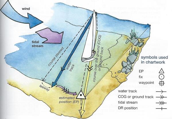
RYA Day Skipper Theory:
Places Available
This course is a comprehensive introduction to navigation, meteorology and basic aspects of seamanship. The course is designed to provide the knowledge required for the Day Skipper practical course. On successful completion of this course you will have acquired the basic navigation skills and general seamanship knowledge which you will need for daylight passage making in local coastal waters. The course includes a general assessment paper and one on chart work.
RYA Day Skipper Theory Course Syllabus
A comprehensive introduction to chart work, navigation, meteorology and the basics of good seamanship.
Nautical Terms
Parts of a boat and hull
General nautical terminology
Rope Work
Knowledge of the properties of synthetic ropes in common use
Anchor Work
Characteristics of different types of anchor
Considerations to be taken into account when anchoring
Safety
Knowledge of the safety equipment to be carried, its stowage and use
Fire precautions and fire fighting
Use of personal safety equipment, harnesses and lifejackets.
Ability to send a distress signal by VHF radio.
Basic knowledge of rescue procedures including helicopter rescue
International Regulations for Preventing Collisions at Sea
Steering and sailing rules (5,7,8,9,10 and 12-19)
General rules (all other rules)
Definition of position, course and speed
Latitude and longitude
Knowledge of standard navigational terms
True bearings and courses
The knot
Navigational charts and publications
Information shown on charts, chart symbols and representation of direction and distance
Navigational publications in common use
Chart correction
Navigational drawing instruments
Use of parallel rulers, dividers and proprietary plotting instruments
Compass
Application of variation
Awareness of deviation and its causes
Use of hand-bearing compass
Chart work
Dead reckoning and estimated position including an awareness of leeway
Techniques of visual fixing
Satellite-derived positions
Use of waypoints to fix position
Course to steer
Tides and Tidal Streams
Tidal definitions, levels and datum
Tide tables
Use of Admiralty method of determining tidal height at standard port and awareness of corrections for secondary ports
Use of tidal diamonds and tidal stream atlases for chart work
Visual aids to navigation
Lighthouses and beacons, light characteristics
Meteorology
Sources of broadcast meteorological information
Knowledge of terms used in shipping forecasts, including the Beaufort scale, and their significance to small craft
Basic knowledge of highs, lows and fronts
Passage Planning
Preparation of navigational plan for short coastal passages.
Meteorological considerations in planning short coastal passages
Use of waypoints on passaged.
Importance of confirmation of position by an independent source
Keeping a navigational
Navigation in restricted visibility
Precautions to be taken in, and limitations imposed by fog
Pilotage
Use of transits, leading lines and clearing lines
IALA system of buoyage for Region A
Use of sailing directions
Pilotage plans and harbour entry
Marine Environment
Responsibility for avoiding pollution and protecting the marine environment
- 5 day intensive course, split weekends, or any other format to suit your timeframe
- All in small groups
Specialist 1-1 tuition by the 1/2 day for brushing up or sorting out those niggling little questions
Weather Forecast